G’day nature lovers, Do you love hiking? I know I do. There is a great hiking track near Nimbin called the Nightcap Historic Track – its the old postman’s track, its 19km long and goes up and over a couple mountains, I’ve been meaning to do it for the past 10 years, but stuff kept getting in the way. Well, I finally did it last week and it was awesome. When prepping for the walk, I discovered a few varying opinions about the walk, I’ve answered some of the important questions for anyone else who is wanting to do this amazing walk.
I first discovered the Nightcap Historic Track 11 years ago, when I first moved to the Northern Rivers of New South Wales. Other than being quite long (19km), and hilly, there is also a logistical problem – its a one way track. I’ve had a few thwarted attempts over the years, mostly held back by bad weather, and finding someone to drop us off and pick us up.
I had done some of the parts of the walk over the years – the Matherson loop and Peates Mountain – but not all the bits in the middle. When I was preparing for the walk there were some conflicting advice, and some lack of info. So I hope I’ve answered most of the important questions here.
What you’ll see
 The Nightcap Historic Track is part of the track that ran between Lismore and Murwillumbah, that was used from 1840’s-1900’s by both postal workers and travellers. Lot’s of people told me before I did the walk, that it was overgrown, and I wouldn’t see anything, this is not true. It is a remarkable walk with multiple ecosystems, massive trees, wildlife and breath taking views of the caldera.
Eco Systems and massive trees
As you walk the track you will walk through multiple eco systems, including: sub tropical rainforest, wet sclerophyll, dry sclerophyll. These eb and flow depending on the aspect, and the soil. You will also see some massive blackbutts, brushbox, strangler fig. As you’re climbing up the Nightcap Bluff, you see a huge burnt out tree, this is the postmans tree.
Wildlife
We didn’t see or hear a great deal of wildlife, but it was mid-winter. We did see pademelon, log runner, grey fantail, king parrot, white browed scrub wren, eastern yellow robin, sulfur crested cockatoo, lace monitor. Apparently there are Albert’s lyrebirds – but we didn’t see or hear them.
Geology and views
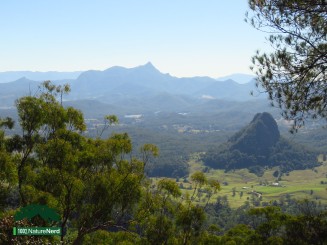
Most of this walk and the views are what’s left from the Tweed Caldera that erupted about 20 million years ago, one of the best preserved erosion calderas in the world. As you start up the Nightcap bluff you will get you first view of Wollumbin (Mount Warning) and discover the Dirangah Rocks, which are impressive eroded volcanic vents.
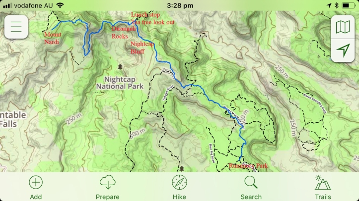
When you get to the cross road for Mount Jerusalem, go to the tea tree lookout, (a great place for lunch) and you will be treated to a spectacular view of Wollumbin (Mount Warning), Doughboy mountain (eroded lava vent), and Mount Tarrawyra. You’ll also get a nice view back to the coast and look right down the barrel of Cape Byron. While there look to the south east, see that big hill – that’s the Nightcap bluff, 839m, you’ll be climbing that after lunch.
How long does it take?
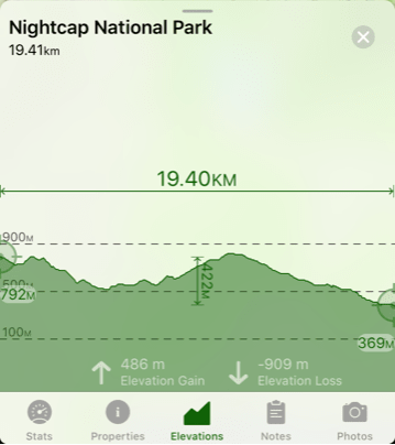
There are several conflicting sources that vary the time from 6 hours to 1.5 days. We did it in 6.5 hours (including stopping for lunch), we were a a bunch of 50+ year olds with moderate fitness. I think 6-7 hours is a reasonable amount of time to allow.
 Do you need to camp?
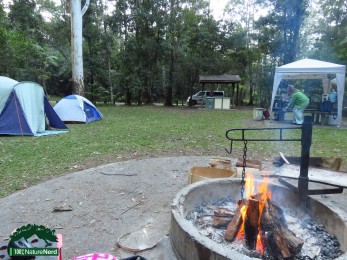
The National Parks say it takes 1.5 days a suggest you camp along the track – you don’t really need to do that, unless you want to walk carrying all your camping gear. We camped at Rummery Park the night before we set off and then when we finished our walk, our camp was already set up. But as it only 6-7 hours, you could get away with not camping at all and go home to your nice warm bed – but where’s the fun in that -oh wait a minute.
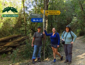
Where do you start and finish?
We started at Mount Nardi and walked to Rummery Park. This is the best way to walk unless you are a real glutton for punishment.
You drive up to Mount Nardi which stands at about 792m, its not quite all down hill from there, but you’ll end up at Rummery Park which is at 369m, you do the maths. In the middle is the Nightcap Bluff, which is about 839m. You can also choose to return via Peates Mountain which stands at 600m, we walked up there the day before and chose not to do it a second time.
Getting there and away?
Mount Nardi, is about 1.5 hours drive from Byron Bay, about 20 mins from Nimbin. You will need to get someone, who isn’t walking to give you a lift and to pick you up at Rummery Park.
Or I have recently been given permission by the National Parks to conduct walks on the track. So, I can offer a transport service to Mount Nardi and pickup from Rummery Park. I’m still working out the details, but give me a call +61405275743 or check out my website visionwalks.com and I will be able to give you a price.
Safety first
This is a hard walk – grade 4, do not do this walk alone. You should be prepared, if you’re not a regular hiker, do a some training that includes walking up and down hills.
- Walk in a group of 3-5
- Carry a topographical map & compass, GPS or we used the Topo Maps+ App
- Carry a first aid kit, and make sure one or more of you is first aid trained
- Carry a personal locator beacon
- Water, I used about 2 litres and that was is winter, I’d allow 3 litres in the summer. There is no where to fill your water on the way.
- Wear long sleeves, especially during tick season (one of our group found 2 ticks)
- Wear a hat
- Check the weather , this is not a good walk if it is wet, parts of the track are steep and slippery.
- Tell someone, where you’re going and when you expect to be back
For more info on bush walking safety check out the National Parks website Bush walking safety advice page.
Other walks nearby
Some other walks that are accessible from Rummery Park Campground include:
- Minyon Falls – loop walk 8km (you’ll need to drive 2 km to the falls or do the Boggy creek walk to get there and the Eastern Boundary trail back)
- Boggy Creek Walk 2km (one way)
- Eastern Boundary trail 2.5km (one way)
- Peates Mountain Walk 7km return
- Quandong (Condong) Falls Walk (2 km) return (can add it to the Minyon loop walk)
- Boomerang Falls Walk 2.4km (return)
Well hopefully you find this information is useful. Enjoy nature.


Looks like a great walk. The view is beautiful.
LikeLike
Looking forward to doing this! Not keen on the ticks though ☺️
Will wait for next winter
LikeLiked by 1 person