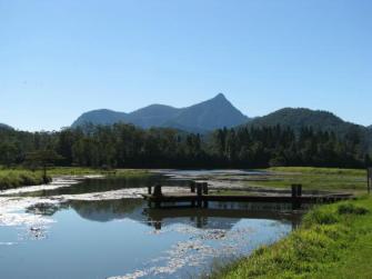
G’day, the Tweed Caldera is arguably the most prominent natural feature of the North Coast of NSW. Mount Warning (Wollumbin) rises 1159m from the centre and the caldera and the mountain ranges to the south, west and north form impressive National Parks crossing the border into Queensland.
Sciencey bit
A Caldera is: a large depression typically caused by collapse or ejection of the summit of a volcano. The Earth: an introduction to physical geology by Tarbuck /Lutgens

The Tweed Caldera is what’s left from a shield volcano that erupted about 20 million years ago, the peak was originally about 2000m high (about twice the current height of Mount Warning) and about 100km in diameter – it was huuuge! National Geographic have stated they think it is one of the best preserved erosion calderas in the world.
Now, we don’t have to worry, its never going to erupt again, and we know that becasue of the way it was formed.
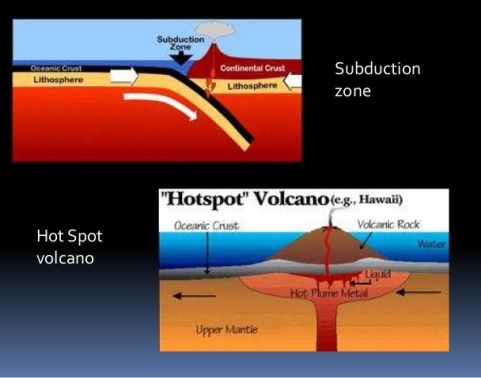
Sometimes volcanoes are created by a process called subduction – this is when a fault or plate goes under another, creates pressure and they erupt e.g Mount St Helens, Mount Etna and Mount Fuji. But that’s not what happened here, what happened here is called a hotspot – this is when a plume of magma finds a weakness in the crust and erupts e.g Hawaii .
The trick is though Australia is moving north at 7cm a year, so every time, this volcano goes to erupt, Australia has moved. So what we find down the east coast of Australia, is a series of extinct volcanoes, the last time this one erupted was Mount Macedon (near Melbourne), about 6 million years ago. The current hotspot is under the Bass Strait, so if it erupts again we’ll have a new island somewhere in between Tassie and Victoria.
Where to see the Tweed Caldera?
There are lots of places to see the Tweed Caldera, Cape Byron, Murwillumbah, Mullumbimby, Mount Jerusalem, Uki, Crams Farm, Border Rangers, Spring brook to name but a few.


But please don’t climb up Mount Warning (Wollumbin), as it is a sacred site for the Bunjalung people and they request that uninitiated people not climb it.
The Tweed Information Centre at Murwillumbah has a great interpretation Centre for the caldera. Explore the caldera from all it’s different perspectives, you wont be disappointed. If you haven’t got a vehicle contact Vision Walks Eco-Tours, they run several walks and tours in the caldera.
Enjoy your journey.


[…] NW from Byron Bay. The falls are a part of the Nightcap Range which forms the southern rim of the Tweed Caldera. You can approach the falls in three main ways, depending on your age and […]
LikeLike
[…] mountain that lies beside the town of Mullumbimby in the Byron Hinterland. It is a part of the Tweed Volcano that erupted about 20 million years ago. It was once covered in wet sclerophyll forest and […]
LikeLike
[…] Big Scrub Rainforest once covered 75,000ha of the Byron Hinterland. It formed on parts of the Tweed Caldera, the big volcano, which erupted about 20 million years ago. The Big Scrub was the largest lowland […]
LikeLike
[…] Bay, about a 45 minute drive. They a part of the Nightcap Range which forms the southern rim of the Tweed Caldera. You can approach the falls in three main ways, depending on your age and […]
LikeLike